What's New
Bug fix...
Bug fix...
Size:
29.4 MB
Category:
Travel
Travel
OS:
iOS
iOS
Price:
$3.99
$3.99
Compatible:
iPhone iPad
iPhone iPad
Requirements:
Requires iOS 5.1 or la
Requires iOS 5.1 or la
Version:
3.2
3.2
Description - Galileo Offline Maps Pro
HIGHLIGHTS
- I have used this with offline maps made with MOBAC..
.
Much easier than Google Maps to use. found in 1 reviews
They added the vector feature close to a year ago. found in 1 reviews
choose from lots of icons to assign to bookmarks. found in 1 reviews
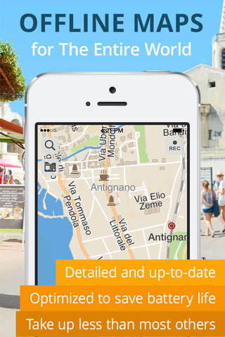
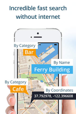
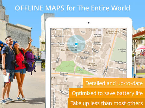
offline vector maps and offline search for your better travel experience. found in 4 reviews
continued use of gps running in the background can dramatically decrease battery life. found in 1 reviews
Touch 2 points and it shows you the distance between them. found in 2 reviews
it finds objects in multiple languages x2013. found in 1 reviews
up to date and accurate x2013. found in 1 reviews
large labels on maps is extremely useful while driving. found in 1 reviews
This is a really cool app for maps and navigation. found in 1 reviews
beautiful gradients to visualise altitude and speed changes. found in 1 reviews
detailed and informative x2013. found in 1 reviews
Fantastic selection of online maps to view. found in 1 reviews
Love this for maps for off-line viewing local AND international travel. found in 1 reviews
If you are iPhone and iPad owner,you now can download Galileo Offline Maps Pro for $3.99 from Apple Store. The application is available in multiple languages: English, Dutch, French, German, Italian, Japanese, Korean, Polish, Russian, Simplified Chinese, Spanish. It weighs in at only 29.4 MB to download. It is highly advisable to have the latest app version installed so that you don`t miss out on the fresh new features and improvements. The current app version 3.2 has been released on 2014-07-11. For ensuring consistency with the device you should take into account the following app compatibility information: Requires iOS 5.1 or later. Compatible with iPhone, iPad, and iPod touch. This app is optimized for iPhone 5.
More Info: Find more info about Galileo Offline Maps Pro in Evgen Bodunov`s Official Website : http://galileo-app.com
More Info: Find more info about Galileo Offline Maps Pro in Evgen Bodunov`s Official Website : http://galileo-app.com
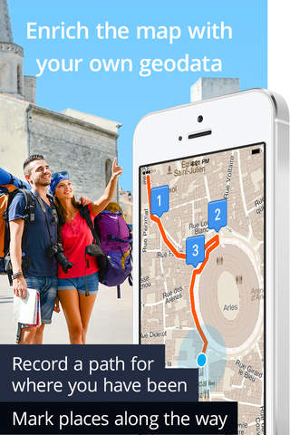
Go offline anywhere you want offline vector maps and offline search for your better travel experience. Our Offline Maps: Totally free there is no limit on the number of countries/regions you can download. Detailed ...
your offline navigation isnt working when not in cellphone service or airplane mode your offline navigation isnt working when not in cellphone service or airplane mode zchais
I ve been using this app when in unpopulated or mountainous areas works wonderfully I also ask if it s possible to make this app carplay compatible Excellent on an Ipad pro Froydor
I want to refund these percashe Refund Aaaaaaaadddddd
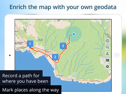
I use it on my iPad in very rural areas My iPad is not on a cellular network yet I can track my position speed elevation and lat long I even tracked myself on a plane going 300 mph I tracked myself on a 4 day hiking trip in the mountains I wish I knew how they can do it but it works great One improvement would be to change the color of roads and highways and trails to make them easier to follow Tracks anywhere even without wifi mr jimz
I have been using this on a long trip through rural Oregon The ability to see your location on a map when you re offline is only the beginning Altitude is handy I used it to track my location while traveling obscure roads and now I will be able to retrace that route There are many other features which I am just starting to explore with the help of the well written user s manual Extremely powerful but easy to use and intuitive Macgenie
Since the late 1990 s l ve used various handheld GPS loggers usually Garmin for weekly hikes around the region and far afield Galileo is the first app good enough to use a phone instead for all except extreme or multi day outings where a phone is too fragile for dependability It records GPS logs with basic statistics and has a good enough filing system to accumulate and organize logs and waypoints Logs are overlaid on its maps and can be color coded by relative elevation or speed It can t generate separate altitude profiles unfortunately Logs can be transferred off phone using Galileo s cloud or e mailed directly by export once saved inside the app as a GPX or KML file The maps are the usual set of OSM choices some with topo lines and or shading and lots of labels The maps are compact because they re in vector format rather than bit maps So one can download an entire large state like CA or a region in just a 32GB Phone Maps for most of the world are available Battery usage while recording is minimal a full day uses less than half the charge in my iPhone 6s unless I m constantly checking the map Great GPX logger compact OSM maps thwarte
Galileo Pro has evolved from a good working offline map to a really stellar performer It s under constant development so the features keep getting better while the maps take up the least space imaginable It s also one of only two apps on the market that imports and exports GPX files correctly I have walked well over 1000 kilometers in Spain using this app Get it Top performer Santiago the Weatherman
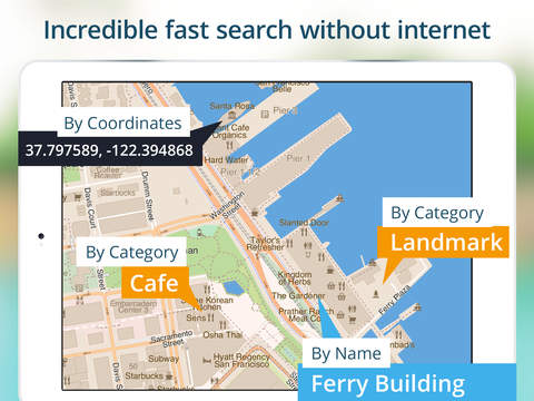
a mapping program that won t look up a street address is useless Useless DJAurand
Overall great app and I use it on daily basis but since last update It keeps crashing every few minutes while recording route to be specific it interrupted my mission route recording 8 times in 1 5hrs Please fix it and review goes back to 5 Crashing after last update Dejan BL
Just got the new fixed version and it works great again New version Crashes fixed pslive
I have no complaints welll it could have directional navigation but it s still really worth every penny Really cool Madame Q
Crashes on ios 10 2 1 Version 3 5 7 HafĂk
I use this app mainly while cycling I create my routes with openrouteservice org and just airdrop the gpx file into this app Have not taken a wrong turn since The offline available vectormap is very detailed better than google maps for hiking etc It would be even greater if opencyclemap can also be stored offline but the app cashes it pretty heavily so even without internet previously visited areas are still available My favorite cycle hiking map app monotonecasper
It the best GPS software in the world because saved my life Good luck Behzad61
I ve been using it for years and it just keeps getting better Lots and lots of updates they are on the ball and constantly updating the app AND updating the downloadable free maps It has small DETAILED downloadable maps that you can access fast require no data other than when you download them and uses less power no data means less power Be sure to download your maps in advance of your trip so you don t eat up your power or data It s great to have a map that does not require data downloads or a signal I travel to Costa Rica often and it s a must have app for down there even in areas with no reception it still works If you download AND select vector maps in advance you will not use data with this app but you have to do this in advance Please understand what this app does It s a digital MAP not a GPS the map will show you where you are not route you just like a big paper map but with a magic dot where you are If you download the vector maps and have the settings set for vector maps it does not need any data I use this on an iPad with no data plan and it works great These are vector maps small detailed scaleable maps These are easily downloadable from the app itself This means with a quick download size varies on state country I have all the details do the the city street and many landmarks Here s the important part if I m in an area of Michigan with no cell coverage I can still view my map because I already downloaded the whole thing You MUST leave your settings on vector or it will try to download maps for whatever setting you are set at My old maps created the hard way still work great but 99 of the time I ll be using these new vector maps The pro version has all of these INCLUDED additional features over the free version Downloading other off line maps this is great and it why I purchased it in the first place you can get maps from different sources and build them on your desktop computer and put them on the device for later I downloaded great maps with heights of the hills mountains for where I hike in Costa Rica I don t need to use international data roaming for this since I built them once and they stay on the device You can also leave bookmarks in the app incredibly useful for marking places that have no other frame of reference You can have it record a path trail for where you have been and view or export where you ve been When hiking I think of it as bread crumbs I miss the old app icon but I m not going to ding the app any points for that These folks listen to feedback so write them with suggestions people complained about the alert notifications and they removed it but the old reviews are still there I ve sent them country suggestions was there a week or two later font size suggestions bug reports and more They re constantly updating the maps and they have WAY more maps available then back in 2014 when they added downloadable maps to the app BEST app for off line map viewing local AND international travel There is NO other app like it Gary LaPointe http://GarySaid.com/
Have relied on this app for multiple hikes now have not been disappointed Yesterday did a winter accent to the treeline of Mt Massive in CO have to create your own trail for most of the climb in the winter and would have been extremely difficult without offline topo maps Easy to use simply create a section using the Mobile Atlas Creator on your computer and transfer into this app Also great for road directions when you are out of service For 4 this is a steal Well worth 4 The Person134
Very useful Offline maps recording routes and straightforward user interface Since finding this app I never had the need to try anything else The best that I know of App lover 676
This app is great for hiking Especially when you are off the grid I use it all the time to track my location and for navigation It s also useful for checking your distance traveled Indispensable Tjallenwood
Only thing is I use if for when I go off roading Wish I could draw on my trail map I loaded and make the my location arrow bigger Great app Obermky
Must have MedvedSV MedvedSV
App is great to have when traveling particularly when connecting to the web is problematic Offline maps don t need an internet connection WiFi or cellular to be helpful in a pinch Glad to have it and I downloaded maps for the states I am likely to find myself in Great to have when traveling Nasrudin
Many poi and works fast Good app LazyFISH~
Pros reasonably easy to use lots of features Cons UI sometimes unintuitive e g settings button in lower right where the location button is in most other maps apps Downloading maps is excruciating over bad connections need to download entire 130 mb file of China to use any map and it automatically pauses the download if connection is bad without resuming when it gets better Generally good benkuhn
In the event of finding myself off the grid and lost I ve always wanted a simple offline map app with which I could find my way back without access to data This is it And more What I ve been looking for Davidbiz
El mejor y adem s muy pr ctico Gracias por vuestro excelente trabajo i Excelente APS~
Been using Galileo actively for about three years and love it I often export tracks to Google Earth to build a virtual map of my property But I just got an Apple Watch 2 and there is no version for it Love it but need a Watch version Sam Pratt
Keeps the maps on the phone Doesn t use up data on your plan Maps detailed and clear Doesn t route via the streets but does draw a straight line to your destination Like a real GPS HarryHydro
We were walking the Camino pilgrim route from France to Spain last year in April I took Galileo with on my iphone loaded with gps waypoints of our route We crossed the Alps at Portalet via a small footpath as we got higher snow covered the track and all I had to go by was Galileo s map to guide us The wife got a bit panicky because there was absolutely no indication of where we were However the map kept us on track for two hours until we saw a very delapidated sign sticking out of the snowtelling us that we were crossing over into Spain From there it was downhill and we were safe How Galileo saved our lives Bloukit
Have used this app several times to locate ourselves when we were without cell service on our phones Super Dave "K"
Awesome app the maps have tons of common features in most areas But I did however find the off road trails for sequoia national park to be a little out of date The GUI is a little confusing and it is often hard to find the feature you re looking for That said I hope the developers add the following features Have crosshair cursor show you elevation as well as GPS coordinates It would be awesome if we could buy more detailed maps of certain areas with the latest trails and information Maybe partner with Tom Harrison maps or nat geo maps Great App for traveling backpacking camping and more Fr3shMint
The best bang for the buck in the map section of the app store Download the vector map of the region you are visiting and you have off line access to info zoomable to the scale where the width of my iphone 6 screen represents about 9 meters 30 ft Choose the POIs you wish to show In remote parts of Africa a wifi only ipad with external bluetooth gps accurately showed my position on off road tracks In foreign cities an iphone shows my location while not registered on any cell network or wifi No roaming charges It does not offer routing but I have never missed that feature Just remember to download the maps you need before you go Galileo pro Notlostnow
This is the only Map I use on my iPad I not only like the fact that its easy to use offline I like the view of the main streets in the larger towns In the 5 Million pop town I live in Ive tried Google and Apple native maps Nothing compared to this Map Great love it
Very useful app when traveling and wandering round places where data costs are absurd or you havent gotten around to picking up a travel SIM Very Useful
I have used this with offline maps made with MOBAC Has been Perfect experience except adding a bookmark doesnt show initially have to leave app and come back Have used this on many trips to make decisions on which trails and roads should be taken Irreplaceable
Up an running in less than 5 minutes Visiting Peru but I could use this anywhere else in the world Excellent
Ive been using it for years and it just keeps getting better Now its got small DETAILED downloadable maps that you can access fast require no data other than when you download them and uses less power no data means less power Be sure to download your maps in advance before traveling so you dont eat up your power or data Its great to have a map that does not require data downloads or a signal I travel to Costa Rica often and its a must have app Please understand what this app does Its a digital MAP not a GPS the map will show you where you are not route you just like a big paper map but with a magic dot where you are If you download the sector maps and have the settings set for vector maps it does not need any data I use this on an iPad with no data plan and it works great They have vector maps small detailed scaleable maps These are easily downloadable from the app itself they are rolling this feature out so you may not see every country yet This means with a quick download 30MB I have all the details do the the city street and many landmarks Heres the important part if Im in an area of Michigan with no cell coverage I can still view my map because I already downloaded the whole thing You MUST leave your settings on vector or it will try to download maps for whatever setting you are set at My old maps created the hard way still work great but 99 of the time Ill be using these new vector maps The pro version has all of these INCLUDED additional features over the free version Downloading other offline maps this is great and it why I purchased it in the first place you can get maps from different sources and build them on your desktop computer and put them on the device for later I downloaded great maps with heights of the hillsmountains for where I hike in Costa Rica I dont need to use international data roaming for this since I built them once and they stay on the device You can also leave bookmarks in the app incredibly useful for marking places that have no other frame of reference You can have it record a pathtrail for where you have been and view or export where youve been When hiking I think of it as bread crumbs I miss the old app icon but Im not going to ding the app any points for that These folks listen to feedback so write them with suggestions people complained about the alert notifications and they removed it but the old reviews are still there Ive sent them country suggestions was there a week or two later font size suggestions bug reports and more Theyre constantly updating the maps and they have WAY more maps available then back in early 2014 when they added downloadable maps to the app BEST app for offline map viewing local AND international travel NO other app like it
I thought Id be able to see several states with detail similar to old fashion paper maps Id return it if I could For me bad choice
I really like how easy it is to record a track and export it to google drive or wherever in KML KMZ or GPX Plus the track highlighting for speed and elevation is cool State map downloads are also much smaller than other offline maps which is nice when storage space is limited Great offline map
Нравится возможность работы с несколькими картами в том числе оффлайн Иногда не хватает прокладки маршрута Не жалею что установил Спасибо Хорошая программа
Great App Wow
Awesome app Im happy
Ive repurposed an old iPhone as a gps to help me get around a foreign country by foot or bike If this app had a routing function Id give it six stars Great app for offline gps functionality
This is a really cool app for maps and navigation I really enjoy using it The cool thing is it has Irans full map Thanks for making this useful app Cool
This replaces my Garmin GPS Maps for hiking and traveling I use this every day to map my treks Must have for hiking
While the app is great theyre constantly releasing the same update to try and get more reviews Great app stop forcing reviews
من اين برنامرو خيلي دوست دارم و براي راهياب استفاده ميكنم چون با حجمه كم تمامه امكانات نقشه ايران رو داره i love this app
I just downloaded the update and lost all my data The app crashed as soon as I opened it It tried to load my data that was in the older app and crashed every time I started the app Removed the app and then reinstalled the app It loaded but when I tried again to load my data it crashed Do not get the update This company is the worst when it come to updates I have had this same problem with many of their updates I will be looking for a more dependable app to use This app is nothing but trouble Do not download the update
Only app that worked offline for me on my iPad Mini on our trip Excellent resource thanks Love it
I recently used this app while traveling in Wales England and Iceland While its not as easy and carefree as using the preinstalled Apple Maps it is quite functional as long as you have basic map skills Its also a tremendous cost saver if you have an expensive international data plan I was able to correctly guide us through all three countries by making numbered bookmarks and navigating number wise to each successive bookmark The maps are very good One improvement that I would like to see to make the app much more functional and user friendly would be including the ability to make a route such as offline marine navigation apps offer It would be the equivalent of tying together bookmarks to get to an end destination That would be super Many thanks to this apps developers for getting me safely to our destination Truly Functional Offline Mapping
I love this app Great app
for navigating routes I use RidewithGPS to layout a route and then transfer the gpx file to GalileoPro to navigate it I love the simple interface I wish it could do routing but what it does it does well Just the best solution out there
Great detail and accurate GPS alignment of maps combined with intuitive interface YachtMaster
Nice app Thanks Excellent
Very very good program and easy to use and we need more updates Omar aljboury
Great app for tracking where you are The base maps have good level of detail Perfect for backpacking
My fiancé and I used Galileo Pro to navigate our way across Costa Rica for two weeks and it worked perfectly We drove from Nosara on the pacific coast to Monteverde La Fortuna then San Jose and never once got lost It was an amazing tool to have and well worth the price for the full version Amazing
I used this app on a recent trip to Chile Whether in Santiago the Atacama region or Easter Island the maps were accurate even down to trails and the tracking was right on Best offline map and tracker
the direction dosent depend on compass it just depend on my movment hope you add an option to depend on just compass Love it
I have used this all over the world Europe and USA and it has been spot on Greatest app
Please find a way to include distance to From current position not a bearing line but actual path by walk or by drive both for online and offline mode This application is so great so amazing that I cant understand why such an important option is still not included Other than that keep the good work going I love this application for real Distance from point to point request
I have been waiting for an app like that for years Only 5 and you have maps for the whole world Best program ever Amazing and trustable offline map
This app has exceptionally fast map redraw speed of its offline maps Import of GPX files is easy and once they add Routing to Galileo it will be a 5 Star App Fastest map redraw
Either this has no way to give directions or it has the most unintuitive interface ever because I couldnt find it No directions
Great work dev Super
Im not one to rave about apps just because but Galileo is really the best app for travellers Download all your maps when you have a WiFi connection and use them everywhere But its the highly intuitive design with excellent features that just work that rate the 5 stars Touch 2 points and it shows you the distance between them Choose offline vs online map modes The new vector map feature with auto download makes it a nobrainer used to be somewhat convoluted and techy to get offline maps before You can use the free version but the Mark Location feature alone is worth the 5 for the package But you can always try the nonpro free version and buy inapp the features that make it essentially the same as the Pro version though I thinkn its logistically simpler to delete the nonPro and install the Pro version once you decide to buy otherwise you will always have the nonProwithinapppurchase version Best 5 I ever spent on an app
Fantastic selection of online maps to view Ability to download free vector maps for offline use is awesome However my biggest use of maps is to go somewhere Need to look elsewhere for navigation features Great map viewer But no routes or nav
向这个软件的编写者致敬他应该是一个户外活动记录爱好者他用心地编写了这个看似简单的软件这个软件延续了视窗windows时代户外手持设备软件的逻辑和要素把户外活动顶尖软件带入iOS时代 具体的优点很多很重要足以写一篇长文但根本的就是它会是我们户外最好的朋友而不仅仅是一个软件 任何时候任何地点的好助手
We travel a lot often in places without an Internet connection This app works fast offline lets us mark the maps with our own notes bookmarks and is very accurate Much easier than Google Maps to use Totally worth it Most Useful
Map and interface look great but it either doesnt work for my area or was not intuitive enough for it to be useable Still looking for an app to use Did not work for my purposes
برنامه خوبيه تا مجانيه زود دانلود كنيد برنامه خوبيه نقشه آفلاين
등산 자전거 탈 때 경로 트래킹용로 잘쓰고 있어요 최고의 앱
By Kostas Gar.